Illustrations are added
C. 1.
Delkeskamp V - Deucker / Borniger 1837
C. 2.
Halenza / Ursinus 1841
C. 3.
Delkeskamp VI - Speyer-Mainz 1842
C. 4.
Delkeskamp VII - Malerischer Reise-Atlas 1844
C. 5. Hoffmeister c.1851
C. 6.
Halenza / Foltz 1865
C. 7. Kapp
/ Hirchenheim (II) 1868
C. 8. Quiel (Halenza) 1894
C. 9. Karl Suder 1900
A note on bridges / buildings / memorials
The following maps were produced post-1836.
At this time there was only one fixed bridge on this stretch of the Rhine; the
so-called Deutzer Bridge was built at Cologne in 1822.
Between 1855 and 1865 three new bridges were
completed. The Hohenzollern
Bridge at Köln was built
between 1855 and 1859; the
railway bridge at Mainz was completed in 1864 according to designs by Gerber; and
the Pfaffendorferbrücke just south of Koblenz was opened in 1864 after three years´ construction.
Cologne Cathedral was incomplete for
centuries before renewed attempts began with the laying o a foundation stone in
September 1842. This necessitated some changes to vignettes. The original
illustration has no towers as such but there is a wooden crane on the left hand
construction which looks to be the second floor of the tower construction.
There is a space between this and the “church”. This gap was later filled so
that the complete construction appeared to have two floors. There were three
towers still to be built; a smaller bell tower on the main church and the two
high neo-gothic steeples on this new left wing.
Neuer Ansicht vom Koelner Dom (Grundstein)
Foundation
stone to Cologne Cathedral completion
|
1842
|
Eisenbahn Koeln – Bonn eingeweiht
Railway Cologene – Bonn opened
|
1843
|
Neues
Museum
Wallraf-Richartz-Museum (New Museum)
|
1855-1861
|
Guerzenich-Umbau in Koeln
Renovation of Guerzenich concert hall in
Cologne
|
1855-1857
|
Koelner Eisenbahnbruecke
Hohenzollern
Bride opened at Cologne
|
1859
|
Koelner Synagoge eingeweiht
Cologne synagogue opened
|
1861
|
Eisenbahnbruecke zu Koblenz
Pfaffendorfer railway bridge at Coblenz
|
1864
|
Mainzer Eisenbahnbruecke (suedlich)
Railway bridge south of Mainz
|
1859-1862
|
Strassenbruecke in Mannheim
Road bridge in Mannheim
|
1867
|
Abbau Kran am Koelner Dom
Crane
removed at Cologne Cathedral
|
29.2.1868
|
Niederwalddenkmal
National Monument at Niederwald
opposite Bingen
|
1877-1883
|
Preussens Koenig Wilhelm II
Monument to King Wilhelm II
|
1878
|
Bismarck Denkmal bei Köln
Statue to Bismarck in Cologne
|
1879
|
Koelner Dom vollendet
Cologne Cathedral completed
|
1880
|
Moltke Denkmal bei Köln
Statue to Moltke in Cologne
|
1883
|
Bluecher
(bei Caub)
Statue to Blucher at Caub
|
1894
|
Neuer Hauptbahnhof Koeln
New railway station at Cologne
|
1896
|
Kaiser
Wilhelm I bei Köln
Monument to Emperor Wilhelm I at Cologne
|
1897
|
Strassenbruecke bei Bonn
Road bridge in Bonn |
1898
|
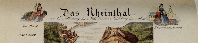
C. 1. Delkeskamp V - F W Deucker 1837
By the mid-1830s the various steel engravers were beginning to specalise in one feature of their art. Hence it was Johann Wolfgang Igler who engraved the titlepiece and it was J Back, who is also crredited with being the printer, who engraved all the text.
Georg Heinrich Carl Deucker was responsible for engraving the map section. He was born on 23rd June 1801 in Niederzündorf which today is a part of Cologne - Köln-Porz-Zündorf . He moved to Frankfurt with his father, a wood carver. He became a copper engraver, studied at academies in Münich and Milan and toured Italy. He returned to Frankfurt in 1830 and proceeded to concentrate on steel engraving. He died in Frankfurt on 2nd. December 1863. Nothing is known about either Borniger ord Collin. (Sattler)This panorama was first published in 1837 with a second impression (identical) appearing in 1839. Check Sattler C6 (1842?).
The author's example illustrated below is dated 1850! This example not listed! Later examples: 1855 with 59 vignettes (Sattler N52); 1862 with 61 vignettes.
Cover title
F. W. Delkeskamp’s neues Panorama des Rheins von Mainz bis Cöln. Mit
Randbildern vermehrt. Also has imprint: Frankfurt a/M., 1850. Im Verlag des Herausgebers F
W Delkeskamp, Zeil, hinter der Rose, D.6. und zu haben in: allen guten
Buchhandlungen des In- und Auslandes. Preis 2 Thlr. Repeated in French on reverse.
Folds into peach paper on printed boards with title in
2 languages – German (front) and French (back), ties lost.
Map title
Title of map is on separately printed leaf: Original Ausgabe Eigenthum des Verfassers (also appears in border
on cover) Friedr. Wilh. Delkeskamp (all capitals in frame, centrally top). Neues Panorama des Rheins und seiner
nächsten Umgebeungen von Mainz bis Cöln. Aufs neue nach der Natur gezeichnet
und mit den interessantesten architektonischen und geschichtlichen Denkmälern
als Randbilder geziert und Herausgegeben von Friedr. Wilh. Delkeskamp in
Frankfurt a/M. Auf Stahl gestochen
unter der Leitung von C Deucker durch Borniger und Collin (left). Repeated in French (right) with below centrally on two lines: Auf Stahl gestochen von F W Igler. Gedruckt
von F Hack. [Printed F Hack, engraved onto steel by F W Igler under the
guidance of C Deucker by Borniger and Collin.]
Superb engraved view of Rhine from Coeln (top) to Mainz with nearly
sixty extra views alongside the river. The whole being 2810 mm in length.
24-page booklet (plus extra advertising leaf) in French, Notes a Consulter pour le Nouveau Panorama Du Rhin, third edition
and dated 1848, in good condition.
One bridge at Köln – Deutzer Brücke, 1822, one bridge at Mainz and
Schiffsbrücke at Koblenz. Railway from Köln to Bonn only.
Size
Cover (h) 180 x 270 mm. Approx. Size of engraved area: 2720 x 260 mm
(with river 235 mm at some points) with 10 mm margins, all other available
space occupied by views (27 left and 31 right).
Steel engraving on 9 plates; 2840 x 253 mm; 60 vignettes (Sattler).
See Flüsse
im Herzen Europas R 50
Sattler, Rheinpanoramen C5 / 7A, B and C and 10B
Holzhäuer Der Rhein im Panorama 10 (p. 56 and 84) and 12 (1851), 13 (1855), 14 (1861)


C. 2. Joseph Halenza / Jean Ursinus 1841
Sattler p.36: From about 1840 there began to be « every year more and more companis of this type » (Delkeskamp). It was increasingly difficult to have an overview of the production of Rhine panoramas. Despite the fact that lithography was becoming a popular medium in printing, until the advent of photolithography in the 1870s steel engraving was still the method of choice. Representative of the numerous other companies in the field were the publishing businesses of two firms based in the city of Mainz: Joseph Halenza und David Kapp.
As Sattler went on to point out for many of these publishers, just as it had been for Friedrich Wilmans and many others in the 19th century, the publishing activities were very much a secondary line of businees. Most of these companies were primarily book dealers and art dealers. Thus it remained for many of the companies who produced travel aids and guide books well into the middle of the twentieth century.
Joseph Halenza founded his publishing house in 1841 in Mainz. His first Rhine panorama from the same year (drawn by Jean Ursinus and engraved by von S J Wolf) was already being printed in its sixth edition by the year 1845. Alongside Delkeskamp this publuisher presented one of the leading firms in the publication of steel engraved panoramas. The company continued in business until the early years of the next century (1900s).
The lithographic map covers the Rhine from Cologne (top) to Mainz (bottom), and is flanked left and right by vignettes. The map was produced on five sections containing thirty-eight views (15 left, 23 right) and title. There are no fixed bridges on the Rhine and no railways. This copy has text booklet in French; also dated 1842.
1. Cover title
Ursinus Rhein-Panorama. Folds into cream
printed boards with floral decoration to border. Title centrally with below Mainz, Verlag von Joseph Halenza. 1842.
Between this and border Frankfurt a. M.,
E. Ullmann´sche Buch-, Kunst- und Antiquariats-Handlung, Zeil, D, 195.
Reverse has floral border and floral decoration and adverts for Joseph Halenza
in 3 languages.
Map title
Attractive panel at base of map (145 x 235 mm) with title Panorama Des Rheins von Mainz bis Cöln above
two columns and arch surrounding view of river. Title repeated left and right
of columns with artist´s signatures in French and English (left and right,
respectively); e.g New Panorama of the
Rhine from Mentz to Cologne by Jean Ursinus Engraving by S J Wolf. Francfort on the Maine (last is very
faint). Printer´s imprint Verlag von
Joseph Halenza in Mainz centrally below.
Size
Cover (with title horizontal) is
140 x 250 mm. Map approx. 1735 x 235 mm; total 1875 x 235 mm (with title
panel).
2. [Names added in manuscript in margins of towns and
villages along the river.
Ursinus Rhein-Panorama
von Mainz bis Cöln.
Folds into grey printed boards with floral decoration
to border. Title centrally with below Panoram
du Rhin Depuis Mayence jusqua Cologne par Ursinus (left) with parallel
title in English (right). Between this and border Mainz, Druck und Verlag von Joseph Halenza. Reverse has floral border and floral decoration centrally.
Not in Flüsse im
Herzen Europas
See Sattler, Rheinpanoramen (notes on page 36).
Holzhäuer Der Rhein im Panorama 20, 21 (p. 93)


C. 3.
Delkeskamp VI - Speyer-Mainz 1842
Cover
title
Neues Panorama des Rheins und seiner nächsten Umgebungen von Speyer bis
Mainz. Also has imprint: Frankfurt a/M., 1850. Im Verlag
des Herausgebers F W Delkeskamp, Zeil, hinter der Rose, D.6. und zu haben in:
allen guten Buchhandlungen des In- und Auslandes. Preis 2 Thlr. Repeated
in French on reverse.
Folds into peach paper on printed boards
with title in 2 languages – German (front) and French (back).
Map title
Not known.
Steel engraving on 5 plates with 31 engravings. It is believed the
panorama was only printed once, hence it is quite rare.
The meandering course of the river is still discernible as the Rhine had not yet had various "straightening" construction. A view that is seldom seen is the one here of Speyer Cathedral (Dom) seen from the southwest and the western feature known as the "Revolutions-Fassade" (revolution facade). This had been completed by Franz Ignaz Neuman, son of the well-known architect Balthasar Neumann, about 1800 and conceived as an entrance element in front of the more roman cathedral structure. The story is that this facade, not fitting in with the other architectural elements,
was little loved. In 1854 the Karlsruhe city architect Heinrich Hübsch
was given the contract to devise a new entrance. This was completed in 1858 and his West Facade is what is still seen today, and more in line wioth the lombardian archway of the East facade. (Sattler)
Size
Cover (h) ##### mm. Approx. Size of engraved area: ##### mm views (###
left and ### right).
Steel engraving on five plates; 1355 x 255 mm; 31
vignette scenes.
Not in Flüsse
im Herzen Europas
Not in Sattler, Rheinpanoramen
Holzhäuer Der Rhein im Panorama 11 (p. 85)

C. 4. Delkeskamp VI – Malerische Reise-Atlas 1844
Cover title
F W Delkeskamp's Malerischer Reise-Atlas des Rheins von
Basel bis zum Meere nebst Supplement-Blatt: Theile von Holland und Belgien, und
die Dampfschiff-Verbindungen mit England erhaltend. Ein Wegweiser für
Dampfschiff-, Post-, Eisenbahn- und andere Reisende. Nach der Natur gezeichnet
mit Randbildern, Städteplänen und kürzer Erklärung.
Cover imprint is: Frankfurt
a. M. 1844. Im Verlag des
Herausgebers F W Delkeskamp, Zeil, hinter der Rose, D. No. 8. und zu haben in:
allen soliden Kunst- und Buchhandlungen.
Folds into plain card boards with intricate arched border in which is
embedded: Original Ausgabe – Eigenthum
des Verfassers. Reverse has
same title in French. One tie present.
1. Map title
Map has no title. Steel engraved view of Rhine from Basel (bottom) to
North Sea with numerous engravings of buildings and town plans both left and
right: there are in fact 152 separate illustrations plus 18 city plans
surrounding the whole, not including the 3 maps of the English Channel,
Haarlemmer Meer. And stretch past Deventer or the illustration centrally of
Rotterdam which separates the above from the main map section. The whole
panorama stretches to 2200 mm. There is a map of the North Sea with the coasts
of England and Holland at top (140 x 170 mm) followed by a section with city
plans of Antwerp and Amsterdam (left) and the part of north Holland from Zuider
Zee to Leyden (right). The next section has a plan of Brussels and the Rhine
from Doesberg to Zuider Zee. Above the top of the Rhine panorama itself is a
city view of Rotterdam. Around and below the whole engraved area are the
vignette views.
Booklet attached (unusually horizontally) with Vorwort (iv), Das
Rheinthal … (22
pages) and Frankfurt und seine Umgebungen (sixty-two pages) the whole entitled Erläuterungen zu Friedr. Wilh. Delkeskamp’s
Malerischer Reise-Atlas des Rheins von Basel bis zum Meere, nebst Supplement:
Ein Wegweiser für Dampfschiff-, Post-, Eisenbahn- und andere Reisende. Nach der
Natur gezeichnet mit 150 Randbildern und 18 Städte=plänen. This has
Delkeskamp’s imprint and address as before and is also dated 1844.
Has one bridge at Köln – Deutzer Brücke, 1822, one at Coblenz and one
bridge at Mainz. Railway is double line and peters out north of Duisburg. Line
from Heidelberg via Darmstadt in direction Frankfurt is double line and stops
half way.
8° Kart. 27806 (151 Randbilder, 15 Stadtpläne). KB.
Size
Cover (with title horizontal) is
130 x 290 mm. Engaved (central) map area is approx. 1780 x 150 mm although some
joining rivers are shown in more detail, the views take up all the remaining
space.
Stahlstich von 6 Platten; 2230 x 265 mm; 150
Randbilder, 18 Stadtpläne (Sattler).
2. Cover has same title but
reprinted with variation: Frankfurt am
Main 1847. Railway continues from Duisburg to
edge of map area and is marked Eisenbahn.
railway lines around Mannheim updated from thin double lines (projected) to
heavy lines: e.g. line from Heidelberg to Frankfurt is complete and black/white
pattern; railway at Speyer; and line from Basel to Offenburg more heavily
shaded.
Booklet has been reset and title page is dated 1848. No mention of
number of illustrations and the beginning is now F. W. Delkeskamp’s Malerischer Reise-Atlas … KB.
Flüsse im Herzen
Europas R51 (although disparity in number
of views and plans).
Sattler, Rheinpanoramen C7 / N51 (1851)
Holzhäuer Der Rhein im Panorama 15 (p. 88), 16 (1851)


C. 5. Hoffmeister c.1851
Cover
title
Malerisches Panorama der Badischen,
Elsaessischen, Main-Neckar & Taunus Eisenbahnen with
added subtitle Gezeichnet und gestochen
von L Hoffmeister in Carlsruhe. Imprint A Bielefield.
Karlsruhe. Plain dark
boards with gilt title.
Map title
This
railway panorama with its very finely engraved side illustrations was produced in Karlsruhe.
It was in all probability published on behalf of the Großherzoglich
Badischen Eisenbahn-Gesellschaft (Railway of the Grand Duchy of Baden), as it was offered for sale at their branches as well as to be had at all book and art dealers.
In 1839 Adolph Bielefeld, who had trained to be a bookmaker, opened a publishing house in Karlsruhe and also operated a bookshop which could offer an English(!) lending library. From 1841 his business operated from Karlsruhe Marktplatz (market square), and from 1856 he was granted permission to offer his services as A Bielefeld's Hofbuchhandlung (purveyor to the royal court). In his sales catalogue of 1881 he was offering 5 panoramas. One of these was on offer as being in French, with an introduction written by the Grand Duke (Großherzog) of Baden; it was in book form, contained 17 views of Carlsrouhe (i.e. Karlsruhe) and also a plan of the city.
All panoramas were from the "engraver to the court" Hofkupferstecher
L Hoffmeister and engraved in steel. He had learnt steel engraving from the well-known Carl Ludwig Frommel .
Size
Cover (h) is approx. #### mm. Area of map detail: 1720 x 285 mm with 63
vignette scenes plus 7 city plans occupying the margin area, no borders. View
of Frankfurt at top.
Not in Flüsse im
Herzen Europas
Not in Sattler, Rheinpanoramen
Holzhäuer Der Rhein im Panorama 18 (p. 91)

C. 6. Halenza, J -
Foltz 1865
1a. Cover title KB
Map
with no title loose inside black boards. Possibly later covers to replace
originals. Bottom of map shows possible signs that leaf is missing (Foltz title
sheet?).
Map title
Folding panoramic map of the Rhine from Mainz (below) to Cologne (top)
total length 2200 mm. Map is very good.
Size
Cover (h) is 175 x 275 mm. Area of map detail: 2200 x 260 mm with
vignette scenes (26 left and 19 right) occupying all the margin area.
Steel engraving on eight plates; 2510 x 265 mm; 45 illustartions, 3 title illustrations, portrait of Friedrich Foltz at bottom of panorama.
Not in
Flüsse im Herzen Europas
Sattler, Rheinpanoramen 13A
1b. Cover title KB
Cover title
is Halenza's
Photo-Rhein-Panorama Von Mainz Bis Cöln. Mainz, Germany:
Verlag Joseph Halenza. Illustrated by
Friedrich Foltz. Cloth Backed Boards. Folding panoramic map of the Rhine from
Mainz to Cologne. Would appear to be an engraving completely covered with
glossy layer to give appearance of photo paper. Early version of map used – two
bridges at Mainz, two at Köln and two at Koblenz. Railway from Köln to Mainz
complete on left bank.
Map title
Der Rheinstrom von Mainz bis Cöln in rectangular frame which forms one part of the title panel below map
(Mainz being below). Title frame surmounts three arches, the left and right
being again surmounted by city arms. Left arch panel has title in English,
right is title in French, each also including vignette view of one of the title
cities. Central
arch is has a dedication: Malerisch
topographisch aufgenommen und in Stahl gestochen von Friedrich Foltz. Publisher’s imprint centrally below:
Verlag v. J Halenza in Mainz. Separate booklet of with text in English by
Fr.Arnold and printed by R Voigtländer in Kreuznach. Last date in text 1866
(p.3).
Folding panoramic map of the Rhine from Mainz (below) to Cologne (top)
total length 2450 mm. Identical to above except for slightly wider format to
accompany gold three-line border.
Friedrich Foltz, der selbstbewußt sein
Bildnis auf den Titel setzte, war auch Mitarbeiter bei mehreren Rheinbüchern
mit Stahlstichen. Ein bekanntes Rheinalbum wurde ebenfalls von ihm gezeichnet
und gestochen. Anscheinend lebte er in Darmstadt.
Das Panorama blieb dreißig Jahre lang im
Programm des Verlags. Es wurde auch als Photolithographie vervielfältigt. Dann
wurde es mit zwei anderen Halenza-Panoramen an den Wiesbadener Verlag Gustav
Quiel abgegeben, der es ab 1896 unter dem Titel „Neuestes Rhein-Panorama“ ohne
den Stahlstichtitel wohl noch einige Jahre nachdruckte.
Size
Cover (h) is 200 x 300 mm. map is 2360 x 250
inside gold border (backing paper) (not incl. title panel). Cover faded
and map is very poor and split in many places. (Now been scrapped!)
1c. Cover title KB
Original title: Halenza's Rhein-Panorama. Der Rheinstrom von
Mainz Bis Cöln.
This
edition: Halenza's Neuestes
Rhein-Panorama Von Mainz Bis Cöln with imprint Mainz, Verlag von Joseph
Halenza inside ornate border. The title Panorama
followed by French (left) and English (right) also on reverse with imprint in
French centrally inside simpler border with additionally printer’s signature Buchdruckerei von J Gottsleben in Mainz.
Publishers
printed cloth backed boards with ties missing.
Map title
Map as above except for additions and changes: three bridges at Mainz (plus pontoon bridge);
Illustration of Dom in Mainz different (three towers visible instead of
only two, left hand steeple has a pointed roof); and Niederwald Monument has been added. Separate
booklet of with text in English by Fr.Arnold and printed by R Voigtländer in
Kreuznach. Last date in text 1866 (p.3).
Folding panoramic map of the Rhine from Mainz (below) to Cologne (top)
total length 2450 mm. One extra view: Niederwald Monument and one view different Dom in Mainz.
New railway bridges at Koblenz (to south) and Mainz (to north).
Projected railway bridge/line south of Bonn. Railway from Köln to Mainz complete
on left bank. Map is very good. Text booklet complete though fragile.
Size
Cover (h) is 160 x 270 mm. Area of map detail: 2300 x 250 mm with
vignette scenes (26 left and 20 right) occupying all the margin area.
Steel engraving on eight plates; 2510 x 265 mm; 45
illustartions, 3 title illustrations, portrait of Friedrich Foltz at bottom of panorama (Sattler).
Not in
Flüsse im Herzen Europas
Sattler, Rheinpanoramen 13A
Holzhäuer Der Rhein im Panorama 26 (p. 95) and 28 (p.96 um 1870), 29 (1875)


C. 7. Kapp, D / Hirchenhein II (with
vignettes) 1868
/ 1877
Cover
title
1. Neues Panorama des Rheins von Mannheim bis
Cöln. Mit 45 Randbildern nebst Beschreibung. Imprint: Mainz. Verlag von D. Kapp, Buchhändler. Zu haben in allen Buchhandlungen. Titles and information repeated on reverse in French (top) and English
(below). Intricate floral frame pattern.
Map title (below)
Der Rhein v. Mannheim
bis Cöln. Gezeichnet und in Stahl gestochen [von] Friedrich Herchenhein. and imprint Verlag D Kapp in Mainz. This final section has two pages, each of three columns; the first and
third columns of the top sheet are taken up with a poem of the Loreley story by
Heinrich Heine in German and each column is headed by a city arms (on a level
with the title). The columns below are taken up with the same poem in French
(left) and English (right). Below the title and in the central column (top) are
an engraving of the Loreley (Die Lorelei) and signature. Below this (central
column of final folding section) are two city views of Cologne and Mainz.
According to Sattler this panorama appeared first in 1868 (the cover was dated) and covered the classic stretch of the river between Cologne and Mainz and was accompanied by 37 vignette scenes in the margins and was printed from seven plateskt. In 1869
the panorama was extended to cover Mannheim requiring an extra printing plate (this issue not dated). When the Kapp publishing house ceased business it was taken over by Halenza, who proceeded to print it and reissued it in updated form until the end of the century. Two significant alterations were the replacing of the head and tail views with new illustrations.
Includes
24-page booklet Anhang zum Neuen Rhein-Panorama von Mainz bis Köln (sic) von
Friedrich Herchenheim. Kapp´s Mainz imprint.
Last date in text is 1877 (page 6); foundation laying of the Niederwald
Memorial.
[Was also printed without the Randbilder.]
dilibri has two copies (?), one early
1869 and a copy illustrated as dated c.1886 (note bridge at Cologne).
Size
Cover (v) is 175 x 300 mm. Area of map detail: 2145 x 295 mm with
vignette scenes (28 left, 17 right) occupying all the margin area. Total length
(incl. poem and 2 views) 2475 mm. Map is good,
poem section stained.
Flüsse
im Herzen Europas
R 58
Sattler, Rheinpanoramen 13B
Holzhäuer Der Rhein im Panorama 25 (p. 94) see also 34
2a. Panorama des
Rheines Von Mannheim Bis Cöln with imprint Mainz,
Verlag von Joseph Halenza. Publishers red cloth
backed boards (Halbleinenband) with gilt title and simple
ornamentation consisting of two vertical lines on left from which flowers are
set. Two small gilt decorations in the right hand corners.
Map title as before but imprint below map is: Verlag v. Joseph Halenza
in Mainz. New railway bridge at Koblenz
(to south) and bridge at Bonn from city centre. Railway from Köln to Mainz
complete on left bank. Two bridges at Mainz and two at Cologne (no 3rd
railway bridge).
New views of Cologne central railway station, National Monument
(replacing Greek chapel), Ems replaced by
statue of K. Wilhelm and the two city views in title
panel are taken from photographs. KB.
Size
Cover (v) is 180 x 105 mm. Area of map detail: 1300 x 90 mm; total
length 1530 mm with vignette scenes occupying all the margin area. Map is good.
Flüsse
im Herzen Europas
R 58
Sattler, Rheinpanoramen 13B
2b. Neues Panorama des Rheins Von
Cöln bis Mannheim with imprint Mainz, Verlag von J. Halenza. Publishers red
cloth backed boards (Halbleinenband) with gilt title and ornamentation within
rectangular border. Cover (horizontal) is 175 x 180 mm. Area of map detail:
?? x ?? mm with vignette scenes
occupying all the margin area.
Goyert copy has 3rd Mainz bridge. (Goyert)
Flüsse im Herzen Europas R 58 (illustration page 28,
wrongly identified as R57).
Sattler, Rheinpanoramen 13B


C. 8. Quiel, (copy of Halenza I) 1894
Sattler (writing about Halenza-Foltz): This panorama remained in the programme of the publishing house for thirty years. It was also copied and printed in photolithographic form. Then, together with two further Halenza panoramas, it was sold to the publishing company of Gustav Quiel of Wiesbaden, who proceeded to publish it from circa 1896 under the title „Neuestes Rhein-Panorama“ and without the steel-engraved titlepiece and was reissued over a number of years.
Cover title
Grosses Rhein Panorama with Germania
(left) view of Rhine (central) and title in gold (central and right), framed
top and bottom with vines. Imprint: Wiesbaden,
Gustav Quiel, Verlag. Back is embossed but mainly plain, khaki boards
Map title
No title. Folding panoramic map of the Rhine from Cöln (top) to Mainz
(below). Fairly primitive printing with views left (18) and right (18),
including Neue Brücke in Mainz. Two bridges at Cologne, none at Bonn, one fixed
bridge at Coblenz (plus pontoon) and only one fixed bridge at Mainz (plus
pontoon). Railway on right bank from Coblenz southwards. Total length 1750 mm.
Size
Cover (h) is 170 x 285 mm. Area of map detail: 1750 x 280 mm with
vignette scenes (36) occupying most of the margin area.
This map appears to predate 1880 but there is a m/s inscription dated 1894.
Not in
Flüsse im Herzen Europas
Not in Sattler, Rheinpanoramen but Sattler does note
that Quiel took over Rhine maps from Halenza.
Holzhäuer Der Rhein im Panorama has a different Quiel panorama 44 (p.
103).


C. 9. Karl Suder 1900
Book title
The Handiest Guide down the Rhine from Mayence to Cologne with Panorama.
Map title
PANORAMA / Vom Rhein – Of the Rhine / Bei K Suder,
Mainz above lithographic Rhine panorama with 23 integrated
illustrations. Besides signature of Moebs (see below, bottom left) there is an
imprint: Erbacherhofsgasse, C Suder
Verlag Mainz (bottom right).
1. This example with English text booklet of 19 pages with a further 11
pages of advertising (HH copy). Bei dem kleinen
Panorama hat sich K Suder eines sehr fein lithographierten Panoramas einer
anderen Firma bedient, denn unter dem Panorama steht: Artistische Anstalt N
Moebs, Rue des Paysans, Mayence. There is a
view of the (new?) Rhine railway bridge in Cöln at the head of the panorama
(but within the border lines).
2. The same panorama, but with an additional ten illustrations, with the same text leaflet lacking advertising block, appeared as a slightly green-coloured lithography. The lithographer's signature below panorama: Lith u. Druck v. Aug. Walter, Mainz.
Size
Cover (v) is ### x ### mm. Area of map detail: 790 x 160 mm with names
on map within a finely drawn margin line.
Not
in Flüsse im Herzen Europas
Not in
Sattler, Rheinpanoramen
Holzhäuer Der Rhein im Panorama 60
(p. 109 and with a reduced facsimile inside the back cover - illustrated here).

K Suder - from Holzhäuer
No comments:
Post a Comment